

US Navy
![]()
Marine Species Monitoring
North Atlantic Right Whale Monitoring
Introduction & Background
The North Atlantic right whale is critically endangered, with about 370 animals remaining in the population. Of those, less than 70 are breeding females. The main causes of their population decline are human factors – ship strike and entanglement in fishing gear. Extensive effort to understand the movements and behavior of this species have been undertaken for over 30 years by organizations along the Eastern Seaboard of the U.S and Canada, although effort has focused primarily on the summer feeding areas in the northern portion of their range, and winter calving grounds off the Southeast United States. For example, the Navy's marine species monitoring program previously funded visual surveys and short-term tagging off the coast of Jacksonville, Florida from 2014 to 2017.
In comparison, the “migratory corridor” along the U.S. Mid-Atlantic has been historically understudied and poorly understood. This page details the contributions of the U.S. Navy Marine species monitoring program to support the monitoring of North Atlantic right whales, focusing predominantly on the U.S. Mid-Atlantic, and specifically on the region immediately adjacent to the mouth of the Chesapeake Bay extending out to the shelf break.
Monitoring in the Mid-Atlantic
A variety of monitoring methodologies are being used to gain a better understanding of North Atlantic right whales, including passive acoustics, aerial and vessel surveys, and tagging. Information on all sightings and detections is contributed to a number of online data portals including WhaleMap and NOAA's Passive Acoustic Data Mapper.
Passive Acoustics
Passive acoustic monitoring has been conducted by the Navy’s marine species monitoring program since 2013 using several different platforms. Initially much of the data collection was intended to establish baseline occurrence of all marine mammal species to inform environmental planning processes, however the main focus has shifted in recent years to monitoring for large whales, and supporting mitigation measures of North Atlantic right whales in particular in order to reduce or avoid Navy impacts to the species.
An array of five marine autonomous recording units were deployed off Cape Hatteras, North Carolina from 2013-2016 to listen specifically for North Atlantic right whales. HARP recorders were also deployed from 2009 to 2021 at several locations on the continental shelf from Virginia through Florida that have been analyzed for the acoustic presence of North Atlantic right whales. These data were contributed to an ongoing project analyzing the acoustic ecology of large whales in the Northwest Atlantic, and were also included in significant collaborative analysis and publication that documented a shift in right whale habitat use after 2010 (see Davis et al. 2017).
More recently, autonomous passive acoustic monitoring for large whales has been utilized in the Mid-Atlantic region beginning in 2019 with Slocum G3 gliders and later shifting to moored buoys. Both systems utilize the digital acoustic monitoring instrument or DMON, a passive acoustic instrument that is capable of recording and processing audio in real time. A low-frequency detection and classification system (LFDCS; Baumgartner and Mussoline 2011) onboard the DMON identifies marine mammal calls and sends data to analysts in near real-time via Iridium satellite communications to verify marine mammal detections. Current and archived deployments can be found on the Robots4whales website, and are listed on the Mid-Atlantic Autonomous Passive Acoustic Monitoring project profile. There have been deployments off Cape Hatteras, North Carolina, and more recently, in the Atlantic off Cape Charles, VA.
A collaboration with NOAA Northeast Fisheries Science Center was initiated in 2022 to deploy arrays of SoundTraps off coast of Delaware and Virginia that contribute to building out a broader PAM network covering the continental shelf break from Maine through Georgia. Ten Soundtraps are currently deployed - a line of 3 extends offshore from the mouth of Delaware Bay, a line of 3 off the eastern shore of Virginia, and an array of 4 units is deployed offshore of SE Virginia. Current and previous deployments can be see in the the passive acoustic monitoring deployment viewer.
Visual Surveys & Tagging
The majority of confirmed North Atlantic right whale sightings off Virginia have been in the mid-shelf region and occurred opportunistically during vessel and aerial-based visual surveys conducted by HDR Inc. Two existing vessel-based projects focus on large whale species, one covering the nearshore and mid-shelf waters off Virginia Beach and the other covering deeper offshore waters near the continental shelf-break. While these projects are focused more broadly on baleen whales (in the mid-shelf region) and deep divers such as sperm whales and beaked whales (in the offshore region), if there is an opportunistic sighting of a right whale then all efforts shift to data collection and identifying individuals, with the potential for collecting biopsy samples, conducting morphometric and body condition assessments, and deploying a variety of tag types. Small unmanned aerial systems (a.k.a. drones) are utilized to help identify the animal, conduct a brief health assessment, check for rope or fishing gear entanglements, and to assess size and overall condition. Satellite tagging, suction cup tagging, and UAS flights off Virginia Beach are performed under National Marine Fisheries Service Scientific Research Permit No. 21482 issued to Dan Engelhaupt of HDR Inc. Duke University is also conducting opportunistic vessel surveys off the coast of North Carolina specifically for right whales. These surveys include towing a passive acoustic array, and may also provide the opportunity to deploy DTAGs (National Marine Fisheries Service Scientific Research Permit No. 22156 issued to Doug Nowacek).
Aerial surveys off the coast of Virginia led by researchers at HDR were added in 2022-23 to increase the likelihood of locating NARW for the vessel to work with. We also coordinate closely with Clearwater Marine Aquarium Research Institute who has been flying seasonal aerial surveys funded by the U.S. Army Corps of Engineers in the Mid-Atlantic region along the North Carolina coastline since 2020. On multiple occasions CMA has provided North Atlantic right whale sighting locations to the vessel team who were then able to locate the individuals to collect additional data or deploy tags.
The research team also works closely with Florida Fish and Wildlife Conservation Commission biologists who assistin confirming photo-identifications both while in the field and following sightings. When in cell range, photos and drone imagery are shared with FWC biologists as a means to confirm suspected ID or determine ID of an individual if unknown. At the end of each field season, photos, video, and drone footage from all right whale encounters are submitted to the North Atlantic right whale Sightings Database and Photo Identification Database maintained and curated by the University of Rhode Island and New England Aquarium respectively.
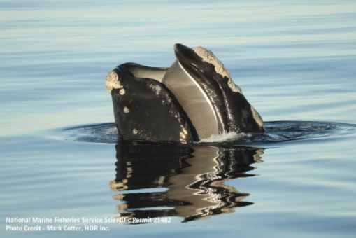 NARW "spyhopping" - a behavior where they poke their heads above the surface in order to get a better view of their surroundings.
Satellite Tagging
One of the types of tags used to collect data is called a LIMPET (Low Impact Minimally Percutaneous Electronic Transmitter) tag produced by Wildlife Computers. These tags are roughly the size of a golf ball and can contain a variety of sensors including temperature, depth, and light, and also track the animal’s movement through either Argos or Fastloc GPS. They are generically referred to as “satellite tags” because they transmit data back to land via satellites.
The current protocol for deploying satellite tags during our Virginia-based surveys is to avoid tagging reproductive-aged females, females accompanied by calves believed to be under one year of age, any calves known to be under one year of age, or whales that appear to be in poor health. Researchers may also opt not to tag whales in social groups because the tags are more likely to be knocked off during social interactions. Suction cup type tags may be deployed on reproductive –aged females since they use a non-invasive attachment.
When a right whale is sighted, the top priority is to photograph the animal and ideally launch a drone to get top down imagery of the animal if conditions allow. The drone images are especially useful in determining the whale’s identity by comparing to a catalog of known reproductive females which is kept on board the vessel for immediate matching. Images may also be sent to collaborators from the field for identification if possible. A visual assessment of the animal is done to ensure that there are no visible injuries or signs of entanglement, and that the animal appears to be in good overall body condition. If photo-identification and the visual assessment both indicate the animal is a candidate for tagging and the animal is behaving in a way that would allow a safe approach, then the team may set up to approach and deploy a satellite and/or suction cup tag.
Following tagging, effort shifts to collecting photos and video from the drone of the tag site and positioning to assess how well the tag attached, orientation of the tag (for suction cup tag calibration), and for follow up comparison of the tag site healing process in the case of satellite tags. Daily updates of a tagged whale’s location are sent to major stakeholders within the right whale community as a means of fostering collaboration and notifying mariners of a tagged whale residing in specific high-traffic areas. Additional sightings and opportunistic photos by the NARW community and others provide the team with a better understanding of the tag site healing process over time.

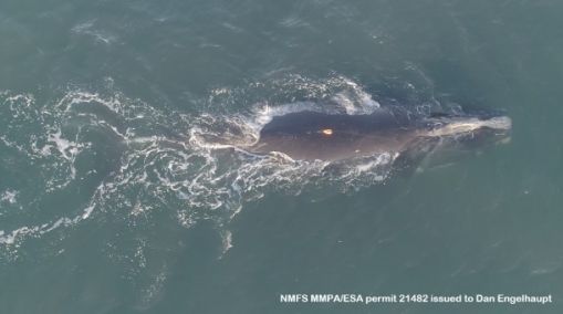
'Smoke' and 'Caterpillar' sighted during an aerial survey off the coast of Virginia on November 20, 2022.
Sightings & Tagging Results
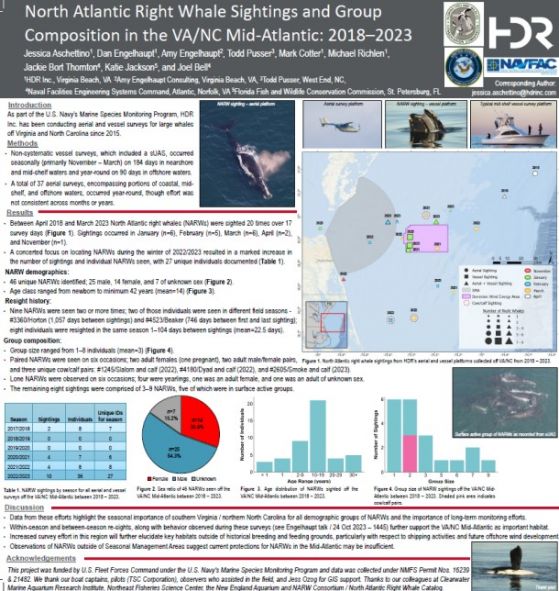
There are currently 80 individual North Atlantic right whales included in the program's western Mid-Atlantic photo-ID catalog through the 2023-24 migratory season. Twenty-two individuals have been seen on two or more days. Interesting resights over time include reproductive female ‘Horton’, sighted 1,057 days apart, reproductive-age male ‘ZigZag’ sighted 49 days apart, female #4610 sighted 487 days apart, and reproductive-age male ‘Eros’, observed on 4 occasions up to 373 days apart. It's notable that relatively large aggregations have been observed in both 2023 and 2024 both mid-shelf and near the shelf break with at least 22 unique individuals (both male and female) identified over a 7-day span in late May 2024. These aggregations have persisted for up to 10 days and suggest that this region is not simply a migratory corridor, but represents an important seasonal habitat for NARW warranting increased monitoring and mitigations.
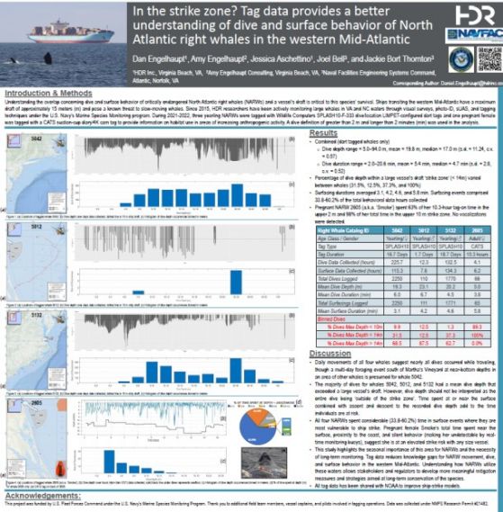
Three satellite tags have been deployed off the coast of Virginia to date – two during the 2020-21 season (NARW5042 (female) and NARW5012 (male)) and one during the 2021-22 season (NARW5132 (male)). Although one tag only lasted 2 days, the other two lasted nearly three weeks each with one animal traveling over 1,600 km to the north along the coast, eventually ending up off Massachusetts, inside Cape Cod Bay, with the last location occurring outside of Boston Harbor. This animal was resighted in Massachusetts during a follow up survey made by HDR Inc. with the help of the Northeast Fisheries Science Center aerial survey team that was flying that day. The same whale has since been sighted by research groups in the northeast US with the tag no longer attached. The tag data has yielded critical information on dive behavior, travel speed, and movement patterns for NARWs in the western Mid-Atlantic.
 'Smoke' with a suction cup tag attached to her back for recording movements, audio, and high definition video.
A suction-cup CATS tag was deployed on a pregnant adult female named “Smoke”, who was later seen with her 2023 calf on her return trip home. See the blog posts below for more information. DTAGs were deployed along with the satellite tags on NARW 5042 and 5012. Two additional CATS tags and two DTAGs were deployed in May 2024 and data analysis is underway.
Here is some fantastic video from that suction-cup tag deployment on 'Smoke' from November 22, 2022.
Progress and results from these ongoing studies was presented at the North Atlantic Right Whale Consortium Meeting in November, 2023 in Halifax, Nova Scotia, Canada. Two posters and a pre-recorded "speed talk" were presented at the meeting, and team members had the opportunity to interact with a variety of stakeholders about our work.

Conservation & Protection
In addition to directly investing in research and monitoring work under the marine species monitoring program, the U.S. Navy also contributes to mitigation planning for North Atlantic right whales in a variety of other ways including financial support to seasonal aerial surveys as part of the Early Warning System for ship collision mitigation efforts in the Southeast, and formal participation on the North Atlantic Right Whale Recovery Plan Northeast and Southeast Implementation Teams.
Blog Posts & News
November 4, 2024 - 2024 North Atlantic Right Whale Consortium Meeting
June 10, 2024 - Whales of Summer
June 3, 2024 - New Right Whale Calf Seen off Virginia
January 30, 2024 - Large Whale Action in the Mid-Atlantic
November 21, 2023 - It's Whale Season in the Mid-Atlantic!
November 3, 2023 - North Atlantic Right Whale Consortium Annual Meeting
May 3, 2023 - NOAA Fisheries highlights right whale tagging work for Whale Week
March 15, 2023- Coming Full Circle- right whale mom returns with calf
February 4, 2023 - Right Whale Party in the Mid-Atlantic
January 18, 2023 - An Urban Whale
November 23, 2022 - Right whales are on the move!
March 2, 2022 - NARW tagged of VA Beach!
March 15, 2021 - Tracking an endangered North Atlantic right whale
January 27, 2021 - Fantastic video of an encounter with North Atlantic right whales off the coast of Virginia Beach
January 19, 2021 - New Acoustic monitoring buoy helps researchers study and protect North Atlantic right whales
April 18, 2018 - Blue whales and sei whales and right whales – OH MY!!
October 18, 2017 - New publication on North Atlantic Right Whale distribution
May 9 2016 - Tagging North Atlantic right whales
March 3, 2014 - North Atlantic Right Whale Disentanglement
October 28, 2013 - Cape Hatteras Field Work Update
October 21, 2013 - Passive Acoustic monitoring for right whales off Cape Hatteras
Project Information
Location: U.S. Mid-Atlantic
Timeline: Ongoing
Funding: $500k+ annually
Points of Contact
Program Sponsor
Laura Busch
U.S. Fleet Forces Command
Environmental Readiness
Program Manager
Joel T. Bell
NAVFAC Atlantic
Environmental Conservation
Marine Resources Section
Deputy Program Manager
Jackie Bort Thornton
NAVFAC Atlantic
Environmental Conservation
Marine Resources Section
Associated Projects
Mid-Atlantic Nearshore & Mid-shelf Baleen Whale Monitoring
North Atlantic Right Whale Monitoring in the Southeast Calving Area

